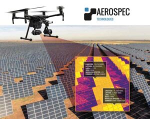
As solar energy becomes a more viable investment, many asset owners are looking to expand their portfolios. According to SEIA, solar has experienced an average growth rate of 49% in the last decade. The operations and maintenance (O&M) providers responsible for the upkeep of solar farms are increasingly using drone technology to conduct system inspections aerially to save time and money as portfolio sizes grow. Drones equipped with thermal imaging systems are used to identify solar module defects and anomalies, completing missions much faster than manual inspections while cutting labor costs. Drone inspection, or aerial thermography, is quickly becoming an invaluable tool for O&M providers. In this article, we will outline some of the best practices for video thermography to ensure that pilots and O&M providers have the knowledge to capture high quality data.
Hardware
A thermal video camera with a minimum of resolution of 640×512, 30hz frame rate, and 13mm lens is necessary to collect good quality data. The most common IR cameras and drone models are the DJI Zenmuse XT, XT2, H20T for DJI Inspire, M100, M200 series, M600, and the newly released M300.
Preparation
It is recommended to perform a test flight prior to arriving on site to ensure that both the drone and thermal camera are functioning properly. Both DJI’s pilot app and Aerospec’s App are capable of creating and executing autonomous missions. If you are using the Aerospec app, verify that it is compatible with your hardware and properly record video data prior to inspection.
Data Collection
Inspections should be conducted on a clear, sunny day. The International Electrotechnical Commission (IEC) TS 62446-3 requires a minimum of 600/Wm2 in the plane of the PV module, with a minimum operating current of 30 percent of rated system current. There should be a maximum 2 okta of sky covered by cumulus clouds, in other words, a clear sky is highly recommended.
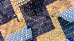
Depending on desired resolution, Aerospec Technologies recommends flying at an altitude of 60 to 150 feet. (See Figure 1) This allows for adequate data capture and processing capabilities while maintaining highest resolution.
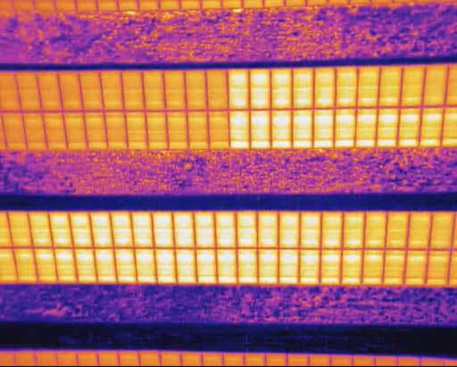
Figure 1. Example of high resolution data capture using video thermography. Flying at an altitude of about 68 feet (or 20.7 meters) Source: Aerospec Technologies
Unlike other technologies used in aerial inspection, Aeropec’s core algorithm analyzes thermal video imaging data instead of individual images. Because video feeds capture 30 images per second for a 30hz camera, data distortion such as sun glare or reflections and motion blur pose minimum threat to data quality. Sun glare becomes clearly identifiable compared to actual anomalies such as hotspots in video thermography as the reflection diminishes in subsequent frames. Likewise, motion blur is insignificant since the increased amount of images make blurring unnoticeable during analysis. Inspections can be conducted at any time with suitable environmental conditions, and pilots are able to fly anywhere from 10 – 25 miles per hour or (4 to 10 meters per seconds) without causing motion blur to the raw data. (See Figure 2 and Figure 3)
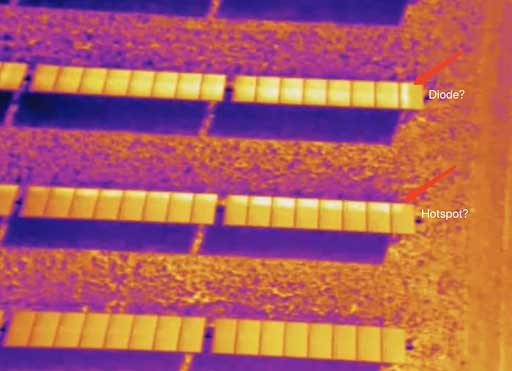
Figure 2. Thermal video at time 0:00 Source: Aerospec Technologies
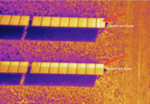
Figure 3. Thermal video at time 0:03. Notice the movement of previously suspect hot spots now suggesting glare. Source: Aerospec Technologies
Data Verification and Delivery
Designed specifically to process video thermography data, Aerospec’s algorithm processes data with high efficiency. Unlike orthomosaic stitching of thousands of overlapping images, captured video data does not need to be modified or assembled in any way prior to being analyzed. As soon as data is captured by the drone, it can be uploaded and processing can start immediately. With the integration of 5G technology, Aerospec will soon introduce near-real time analytic tools to help solar farm operators to process data while the drone is still in the air.
The average delivery time for analysis reports ranges from hours to up to within a week depending on solar farm sizes. For urgent needs such as commissioning inspection, Aerospec can perform batched analysis and provide actionable insights for clients at an even faster rate. For example, a 250MW solar farm can start receiving reports within 48 hours after initial inspection data has been uploaded to Aerospec’s cloud system.
If you are interested in learning more about how aerial thermography can save time and money on your next inspection, please contact us at www.aerospec.us for more information or to schedule a demo today.